Sunday, March 29, 2009

Coyote Wall - March 28, 2009

Coyote Wall is located in the Columbia River Gorge approximately 3 miles east of Bingen WA. The trail we took was 8.75 miles with an approximate 1,700' elevation gain.

This is of the Columbia River taken near the trailhead prior to ascending Coyote Wall. Taken at 8:30 a.m., a bit ominous for that time of day....

Trailhead starts through an old cattle chute.
Here is a pic of Ginger takin' in the views of the Columbia River beyond the wildflower meadows. Here is what she is lookin' at...

Ginger tellin' me, "Come check out the view!"

"You're right, Ginger! The view is spectacular!"

Feelin' a little spunky, as I never dreamed of being able to accomplish this trek!
"THE VIEW!" ...gosh, I'm speechless...
Based upon our emergency rescue last weekend at Tom McCall Point, we thought to scout out the nearest natural helicopter pad....just in case! :)

These wildflowers are far and few between, but very lacy and dainty... Smooth Prairie Star (Lithophragma glabra)
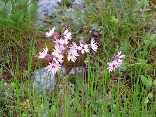
This tree reminded me of an old western movie. I don't know why, it just did.
The brightess & greenest moss I have ever seen!

Camas WA - March 26, 2009

Went for a 5 mile walk with a 770' elevation gain after work, starting at home, and allowing my legs and eyes take me wherever they wanted to go...

Came across this critter on my walk...

Tom McCall Point - March 21, 2009

Tom McCall Point is located in the Columbia River Gorge on the Oregon side near Mosier, OR. The trail we took was approximately 3 miles round trip with an 1,100' elevation gain.

Beautful view approximately 3/4 of the way up.
At the summit of Tom McCall Point
Orange lichen

Grass Widow

I invited my neighbor along for the hike, and she unfortunately slipped in the mud, shattering her ankle. Rescue personnel were wonderful, and the scenic plateau below, made for a natural helicopter pad.

Lyle Cherry Orchard - March 14, 2009

Lyle Cherry Orchard in the Columbia Gorge near Lyle WA. The trail we took was approximately 5 miles round trip with 1000' elevation gain.
Grass Widow (Sisyrinchium douglasii var. inflatum)
Gold Stars (Crocidium multicaule)

Heritage Trail @ Lacamas Lake - March 6, 2009

Heritage trail is located within the City of Camas, WA and is a heavily used 6.5 mile scenic trail.

On the US National Register of Historic Places is the Leadbetter house on the North shore of Lacamas Lake.

The Queen Anne Victorian style farmhouse, circa 1901, overlooking Lacamas Lake was a wedding gift from Henry L. and Georgiana Pittock (Pittock Mansion, Portland, Oregon) to their son, Frederick, and new bride, Bertha Leadbetter Pittock.


Mt. Hood


Miniature waterfall


Rodney Hardy Falls - Feb. 28, 2009

On our way home from Aldrich Butte, we stopped to check out these falls. Aproximately 2.5 miles round trip and 400' elevation gain.


Aldrich Butte - Feb. 28, 2009

Overlooking the Bonneville Dam from an old fire lookout and WWII defensive position. This trail was approximately 3 miles rountrip and 600' elevation gain.


Ashley is not thrilled with mom at the moment, as she'd rather be in her warm and comfy bed.


Here is the view from the summit...Bonneville Dam to the east

Beacon Rock to the west...

Ashley, offering Kayla a shortcut down to the car...

The old WWII gun mount, in curiously good condition.

I discovered an old photo of the road work in 1942, up to the WWII defensive position...

Photo credit: http://digitalcollections.lclark.edu/cdm4/item_viewer.php?CISOROOT=/civ_photos&CISOPTR=251&CISOBOX=1&REC=16


The roadwork needs a lot of repair these days!

Greenleaf Overlook - Feb. 21, 2009

Greenleaf Overlook, from the Pacific Crest trail. Approximately 8 miles round trip and 800'elevation gain.

A little catching up to do...

I have recently taken up the hobby of hiking. It all began when I brainstormed an idea of pairing my passion for photography and my quest for a healthy body. Since I began hiking a little less than 2 months ago, I have lost 18 pounds and 6% body fat.

With much prodding by my sister-in-law, I have now created my hiking/photo expedition blog. However, the chore is to now post pics of the past few hikes in order to get updated.